District Poonch is located to the south-west of—and across the Pir Panjal range from—the Kashmir valley. In 1947, after the first war between India and Pakistan over Kashmir, the district was cleaved into two, with its western part forming a part of Pakistan-administered J&K (PAK) and its eastern part coming under Indian-administered J&K. The part under Indian-administration shares its borders with Rajouri district to the south. Badgam, Shopian, Kulgam and Baramulla are the four districts of the Kashmir valley which touch the borders of Poonch, the first three to the east and the last one to the north. Poonch stretches between 33°25’ to 34º01’ north latitudes and between 73°58’ to 74º35’ east longitudes. It is about 180 kms away from Srinagar, the summer capital (via the Mughal Road), and 240 kms away from Jammu, the winter capital of the state. The district, historically and culturally closely connected to Kashmir valley, is part of the Jammu province.
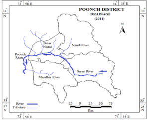
Poonch is drained by a number of rivers, streams and rivulets. River Poonch is the largest and longest of them. It is 245 kilometres-long from its source in Pir Panjal to its destination. It originates from the Katorsar Lake, in the vicinity of Girjan Dhok (meadow), situated at an altitude of more than 4,200 meters. From Katorsar to Behramgala it is known as Parnai Nallah. Chhata Pani, a small stream emerging from Look Sar in the vicinity of the Pir Panjal pass, merges with the waters of Parnai Nallah at Behramgala. A small stream called “Mahra River” or “Hill River” coming from village Mahra joins it at its left bank. At Bafliaz, another stream coming from Hill Kaka track known as Akal Katha and Chang Nallah joins with Parnai Nallah and it takes the shape of a river. From Bafliaz to Kalai this river is known as Suran River. Sangla Nallah joins the Suran River near Pamrote and Bandhalli Nallah near the village Phagla. At Chandak, the Pulust Nadi coming from Loran, Gagrian and Mandi side meets with Suran River. Drungali Nallah joins it on its right bank near Nangali Sahib. From Chandak onwards this river is called the Poonch River.
As per Kalhana’s Rajatarangini, the ancient name of the river was Toshi River. Another stream, Betar Nallah, which starts from the slopes of Haji Pir (8,600 feet), after passing Chanjal, Alibad and Kahuta in PAK, enters Indian administered side in Degwar village and eventually merges with the waters of the Poonch River near Purani Poonch. Adimba Jali coming from Bandi Abbaspur (PAK), joins the Poonch River near the village Dharamsal and Hajira Nallah at Madarpur. River Poonch enters PAK at Tetrinote-Salotri village. After passing Mandla and Kahuta, Mendhari stream, coming from the slopes of Shah Star ridge, merges with the waters of the Poonch River near Tatta Pani Village. After crossing Kotli Town (PAK), River Poonch merges with River Jhelum. Another Nallah, Mahil which passes through Tehsil Bagh of PAP is about 35 miles long. The source of this river is Ganga Choti. The total length of then Poonch River is 245 kms.
Advertisement